Mayor Anne Hidalgo has announced an “almost philosophical project” to take the famed river’s quayside back from cars.

Paris seems to be getting less and less motorist-friendly by the day. Following a set of promises to slash diesel usage, extend lower speed limits and bar polluting cars from the city core, Mayor Anne Hidalgo announced a plan to thoroughly reclaim the quayside on the right bank of the River Seine for pedestrians. With cars already banished from a long strip of the Left Bank, the Seine in central Paris will as of summer 2016 be entirely encased within two lush, motor-free parkland buffers. Sounding more French than ever, Hidalgo described the plan as “an urban, almost philosophical project, which consists of seeing the city in another way than through the use of cars.”
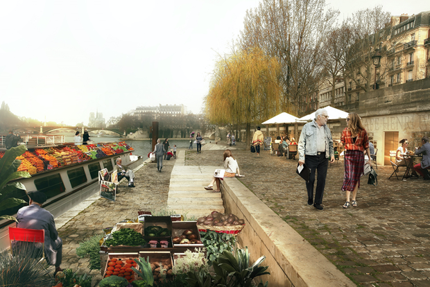
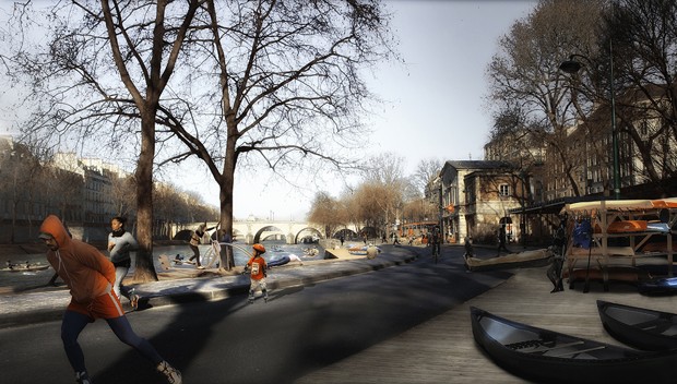
This is about far more than making things tough for drivers, however. The space freed up from redirecting cars will be broad enough to create a wide promenade, shaded by trees and with space for children’s playgrounds and sports facilities. Covering up to 3.3 km kilometers in total*, this green border will create up to 1.4 acres of new parkland while simultaneously reducing pollution. Judging by the renderings available, it’s going to look and feel delightful. The plan will also correct one of the worst planning mistakes Paris made in the 20th century (more of which later) and, perhaps best of all, probably cost no more than €8 million ($9 million).
“This is about far more than making things tough for drivers.”
Exactly how long the new quayside park will extend is still up for grabs until a public consultation this June decides on one of two plans. One plan covers a modest 1.5 kilometers, pedestrianizing the stretch between the eastern end of the Ile St. Louis and the western tip of the Ile de la Cité. The other is far larger, creating an additional 3.3 seamless kilometers of car-free quayside from the Pont de l’Arsenal (due South of the Bastille) up to where the riverside road plunges into a tunnel at the Tuileries Gardens, where the quay is already for walkers and cyclists only.

That this is possible without snarling Paris traffic terribly is due to the Seine’s distinctive double-tiered embankment. The Seine actually has two separate lines of quayside. One stands above the river at street level and the other is right down on the water, sunk below high walls that separate it from the rest of the city. These two levels created a split personality for the river as it was steadily formed by embankment from the 17th century onwards. While the upper level became an attractive, salubrious promenade populated by strollers and booksellers’ stalls, the lower bank remained a commercial affair where barges offloaded their cargo.
From our partners:
This changed in the 1960s when, pursuing what was then considered good policy, Parisian planners started looking for new ways to speed cars into the city center. The existence of the un-built lower quays must have seemed miraculous back then—Paris could find space for four new traffic lanes without even having to demolish a single building. Certainly, converting them into roads was a lot less destructive than what took place in other cities, so often a slash and burn carving of new motor lanes into the historic fabric. At least the roaring noise the new mini-highways created was muted by being sunk down below embankment walls, while some stretches were actually encased in tunnels. Nonetheless, something was unquestionably lost. Beyond far dirtier air for central Paris, people seeking out the city’s sense of romance found themselves looking down from ancient bridges onto a screeching speedway.

The long overdue turnaround began in earnest just after the millennium. In 2002, Paris started closing down sections of the quayside to create a temporary summer beach, complete with real sand and sun loungers. Now spread to three sites along the river, the Paris Plages scheme hasn’t just shown how delightful the riverside can be, it has proved that the city could divert motor traffic without kick-starting Armageddon. Taking note, the city barred cars permanently from a long stretch of the Left Bank in 2013 to create a waterside park. The results of this plan are already impressive: 4 million visitors in its first 18 months and a 15 percent reduction in local nitrous oxide pollution.
While this sounds great, opponents point out an obvious pitfall. Closing down motorist routes doesn’t automatically reduce pollution—it can also just displace or intensify it in other places. So what will Paris do if cars banned from the quayside start to clog up other roads even more? Hidalgo is promising an as yet un-clarified improved public transit offer to help mop things up, but overall she suggests that the best new alternative location for cars may be the scrap yard. Discussing plans for future traffic flow, she had this to say:
“All this is part of a comprehensive policy in which we assume very deliberately that there will be fewer cars in Paris. Therefore in calculating the flow of spillover traffic I don’t project myself into a world where there are as many cars as today. Objectively that will no longer be the case.”
This feature is adopted from CityLab.


