Browsing Tag
Maps
37 posts
Map-related materials.
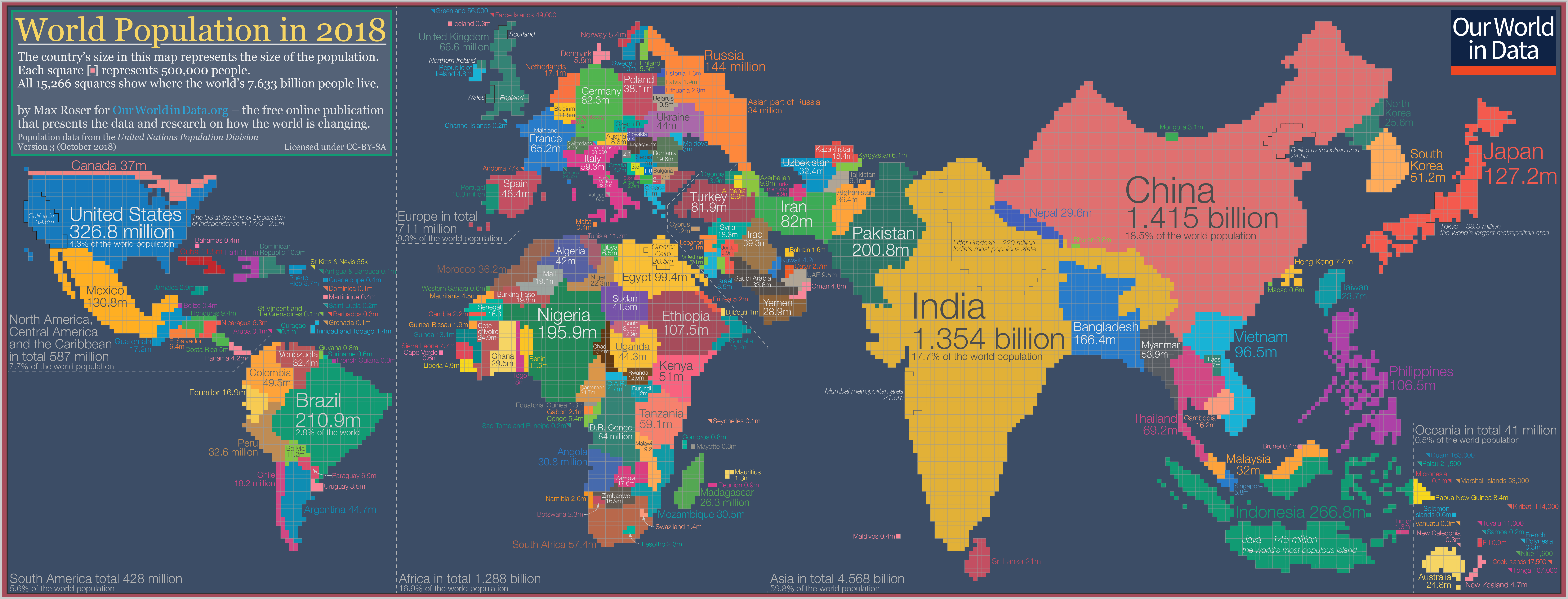
If Countries Were As Large As Their Populations, Here’s How The World Would Look Like
Maps are great instruments for navigation. However, they have little to say when it comes to describing how…
2020-01-16
Here Are The Real Boundaries Of American Metropolises, Decided By An Algorithm
How is the U.S. actually split geographically? When we think about where we live, usually our ideas start with…
2018-10-15
Multidimensional Maps That Provide New Perspectives On New York City
The world’s most mapped city, as you’ve never seen it before. THE UPPER EAST SIDE IS literally leafy. Pear,…
2018-09-20
Where Are The Hipsters In Your City? These Crowdsourced Maps Will Show You
Hoodmaps offers a crowd-sourced mapping platform that gives users the ability to walk through a city like a local.…
2018-08-20
Learning About Cities By Mapping Their Smells
The English artist Kate McLean is trying to preserve our olfactory memory. Each of us probably has one:…
2018-08-17
The Transportation Problem No One Is Talking About
Right now, most self-driving cars–like those being developed by Google or Uber–can only operate in very limited urban…
2018-05-24
AI Is Reshaping What We Know About Cities
Machine learning is helping urbanists confirm–or disprove–long-standing theories about cities. Why do certain neighborhoods feel safe while some feel…
2017-11-02
How Maps Became Deadly Innovations in WWI
Advances in weaponry and cartography had deadly repercussions in World War I, which the United States entered 100…
2017-08-25
Here Are The Best Cities For Digital Nomads
The one thing truest about technology is that it is always evolving. These days, technology is more accessible…
2017-06-26
U.S. Salary Inequality From Productivity Not Just Tech Boom
Employment may have rebounded since the Great Recession, but the staggering regional gaps in both real wages and…
2017-06-22
The 10 Maps Of Exquisite Beauty And Elegance
During much of history, maps were designed as much for beauty and display as for accuracy. When maps…
2017-03-28
Train Buffs Will Love This Atlas of Railway Photography
The map, created by a self-professed rail geek, plots geotagged train-related Flickr images. Nick Benson is a self-professed…
2015-08-31
Where We Should And Shouldn’t Build Roads In The Future
“Road Map” shows where economic benefits from roads are as high as the danger they pose to the…
2015-07-21
Enjoying Mobility In Stuttgart
Stuttgart has set an aspiring goal when it comes to mobility on two wheels: the long term, the…
2015-06-12
Apple WWDC 2015 : Solutions For The Urbanites
Apple’s WWDC 2015 has begun. The annual event where Apple launches new releases, major updates and products and…
2015-06-10
The Shortest Paths To Happiness
Figuring out how to walk quickly from A to B is easy. Just plug two addresses into your…
2015-06-02
Where To Find The Quietest Places
New data from National Park Service scientists shows that “most people live in environments where night skies and…
2015-05-29
3-Year Dedication Of Mapping Brooklyn Made From Trash
Jennifer Maravillas’ “71 Square Miles” is one of the most colorful maps of Brooklyn I’ve seen. And it’s…
2015-05-28
How Fractals Bring Imaginary Cities To Life
Emily Garfield like to say that she grows cities. With pen, ink, and watercolor, the Boston-based artist creates…
2015-05-25
Mapping The Age Of Every Building In Manhattan
A tool called Urban Layers tracks Manhattan’s rise, block by block, since 1765. The Harlem Renaissance was the…
2015-05-16
Mapping The Morning Rush Hour In US
In Nevada, you’re likely to leave for work between midnight and 5 a.m. The time you decide to…
2015-04-20
What Your City Would Look Like In Tron
Stacks of geometric blue shapes represent skyscrapers. Cars become shooting yellow dashes moving across the landscape. Undeveloped land…
2015-04-17
Dave Troy : Social Maps That Reveal A City’s Intersections & Separations
Every city has its neighbourhoods, cliques and clubs, the hidden lines that join and divide people in the…
2015-04-14
Daniele Quercia : Happy Maps
Mapping apps help us find the fastest route to where we’re going. But what if we’d rather wander?…
2015-03-27
The Evolution Of Urban Planning In 10 Diagrams
Le Corbusier’s plan may not have had such power if he hadn’t put it on paper. The French…
2015-03-25
The Insanity Of City Street Grids
A new data visualisation reveals exactly how serpentine some cities’ road patterns can be. Stephen Von Worley—whose previous…
2015-03-19
Missing Maps: A Human Genome Project For Cities
A huge number of the world’s most vulnerable human settlements have remained unmapped … until now. Enter an…
2015-03-09
Visualising The City Of Barcelona
At night in Barcelona, Gaudi’s Parc Guell lights up, and the little restaurants in Las Ramblas hop with…
2015-03-05
Talk Of The Town : Society Is Abuzz
What do the social networks look like in your city or country? Dave Troy (TED Talk: Social maps…
2015-03-02
MIT Is Drawing 10,000 Maps To Save The World
The social computing group wants to initiate social change via data visualisation at the rate of a map…
2015-02-26
Chicago, The Last Great Capital Of Cartography
As America grew in the late 19th century, so did mapmaking—and Chicago was at the heart of it.…
2015-02-26
Every City Should Have Something Like San Francisco’s Mass Transit Access Map
It lets you see exactly how much of the city you can reach in a given time window.…
2015-02-25
What Old Transit Maps Can Teach Us About A City’s Future
An analysis of once-rejected, later-constructed routes in Los Angeles, Atlanta, and Houston. Houston, Atlanta, and Los Angeles are…
2015-02-14
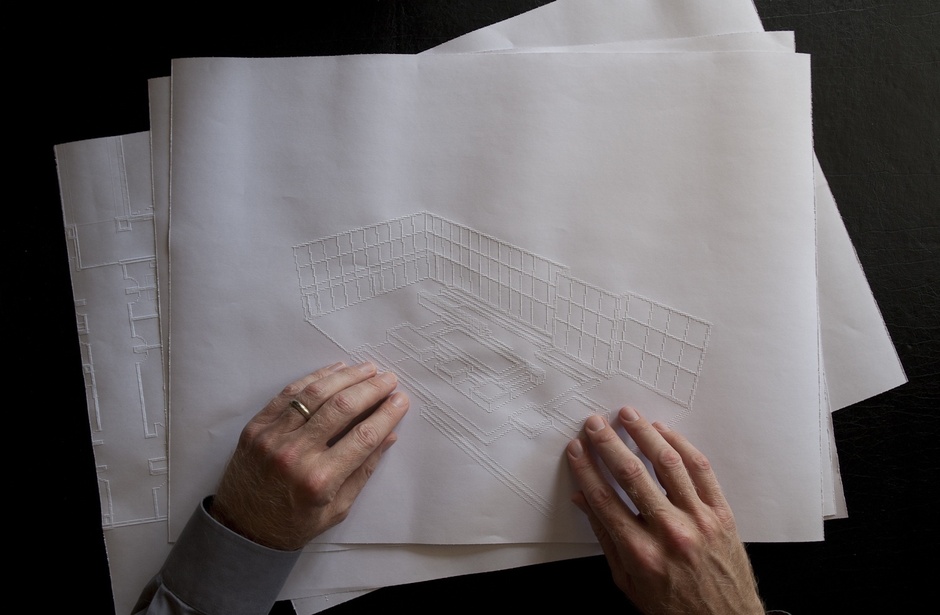
Maps That You Can Hear And Touch
Scientists and architects are pioneering a new cartography for blind users. Sighted people read maps almost every day.…
2015-02-10
How Brooklyn Is Like Buenos Aires: Toward A Science Of Cities
Marc Barthelemy and Rémi Louf, researchers at L’Institut de Physique Théorique outside of Paris, are seeking quantitative approaches to understanding cities.…
2015-02-09
London’s Near-2000 Year History Mapped
Researchers at UCL’s Centre for Advanced Spatial Analysis collated vast datasets to map the capital’s transformation from first-century…
2015-02-05
City Maps Through The Ages
From London’s cholera outbreak to the siege of Frankfurt, these are the works of the earliest data gurus, who…
2015-01-29


